My Store
CHCNAV Guide-10 GPS Navigation: Advanced Solution for Precise Mapping
CHCNAV Guide-10 GPS Navigation: Advanced Solution for Precise Mapping
Couldn't load pickup availability
Discover the CHCNAV Guide-10 GPS Navigation: Your Advanced Mapping Solution
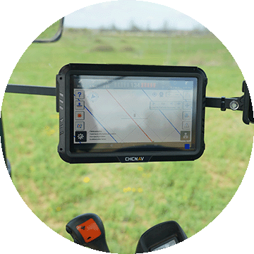
The CHCNAV Guide-10 GPS Navigation is an advanced solution designed for precise mapping needs. Whether you're a seasoned professional in surveying or tendering for geographical analysis, this GPS navigation system offers cutting-edge technology to cater to all your navigation requirements.
With the CHCNAV Guide-10 GPS Navigation, you can expect unparalleled performance and accuracy. Engineered with robust features, this device stands out in the saturated market of GPS systems.
Key Features of CHCNAV Guide-10 GPS Navigation
- High Accuracy: Enjoy precision mapping with an accuracy level that meets professional standards, ensuring you can rely on your readings.
- User-Friendly Interface: The intuitive design and straightforward navigation allow anyone, regardless of their level of expertise, to operate the system effectively.
- Rugged Design: Built to withstand tough conditions, the CHCNAV Guide-10 is perfect for outdoor professionals who need reliability in varying environments.
- Versatile Applications: From agriculture to construction, this GPS navigation tool serves multiple fields, adapting to your specific project needs.
Unmatched Performance
The CHCNAV Guide-10 GPS Navigation is equipped with state-of-the-art technology, including enhanced signal reception and superior satellite tracking capabilities. This means that no matter where you are, you can expect consistent and precise location data. This device caters to a wide range of applications, making it an essential tool for engineers, surveyors, and outdoor enthusiasts alike.
Easy to Use
The streamlined interface of the CHCNAV Guide-10 GPS Navigation makes it accessible to users of all expertise levels. The large display is clear, presenting critical information without overwhelming the user. With easy-to-follow menus and quick setup processes, you'll be up and running in no time.
Durability for Every Environment
Constructed with durability in mind, the CHCNAV Guide-10 GPS Navigation can withstand harsh weather and rugged terrain. Its robust design ensures that it will perform reliably even in challenging environments, making it suitable for outdoor adventures and demanding work sites.
A Multi-Purpose Tool
Whether in the agriculture field, during construction projects, or surveying new land, the CHCNAV Guide-10 GPS Navigation proves its versatility. The GPS system adapts seamlessly to various tasks, giving you peace of mind that you have the right tool for the job at hand.
Join the Community of Satisfied Users
Many professionals have transformed their mapping and navigation precision with the CHCNAV Guide-10 GPS Navigation. Users rave about its reliability and accuracy, which significantly enhances their productivity. Don’t miss out on the opportunity to elevate your projects with the superior tech of this GPS navigation solution.
What Sets CHCNAV Apart?
CHCNAV stands for innovation. When you invest in the CHCNAV Guide-10 GPS Navigation, you are choosing a product backed by years of research and a commitment to excellence in mapping technology. The company’s reputation for quality stands tall within the industry, ensuring your investment goes a long way.
Technical Specifications
Here are some key specifications of the CHCNAV Guide-10 GPS Navigation:
- Frequency: L1, L2
- Accuracy: Up to 2 cm in real-time
- Weight: Lightweight
- Communication: Bluetooth and Wi-Fi connectivity
Ready to Elevate Your Navigation Experience?
Don’t settle for less when it comes to navigation solutions. The CHCNAV Guide-10 GPS Navigation is not just a tool; it’s an investment in precision and quality. Perfect for professionals and outdoor enthusiasts alike, this GPS navigation system will elevate your projects to the next level.
Upgrade your GPS navigation experience today! Click here to purchase your very own CHCNAV Guide-10 GPS Navigation and start enjoying precise, dependable mapping solutions.
Share